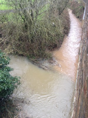
The Somerset Frome Diffuse Pollution Pathways project will use a risk grading approach to develop sediment pathway maps for the upper Somerset Frome (South of the town of Frome). To date, statutory monitoring programmes and local knowledge has been used to identify the main pressures and likely reasons for failure to meet water quality standards. However, this existing data can often be insufficient for providing evidence for effectively prioritising and targeting works which will reduce sediment load and nutrients entering the watercourse.
Thanks to funding from the Bristol Avon Catchment Partnership, the project will involve a series of wet weather walkovers to identify pollution pathways using the Source Pathway Receptor Principle. These pathways can be identified by colour changes from ditch, road or tributary inputs into main streams or simply the colouration of the input itself if the main stream is already coloured.
Data collected at all sites will include GPS coordinates and photographs and where possible pollution events will be traced to source. The walkover survey findings will be graded according to their severity and risk to sediment entering into a watercourse.
Useful data sets including LIDAR images and the location data collected will be used to create maps of the area. The completed risk maps will highlight areas within the project area where it is likely that different cropping, better soil management or physical interventions would have the greatest impact of reducing soil and nutrients entering the river.
Stakeholder engagement will be an important part in developing solutions identified by this project. BART will engage with the general public, landowners, farmers and local businesses to increase awareness of the issues surrounding erosion risk and diffuse pollution as groundwork for future interventions.
What can you do to help?
We can’t be everywhere in the catchment at once but we are keen to get as much data as possible to build up knowledge for future improvements. If you are passing the area please help us by:
1. Reporting areas where sediment is entering the river. This may be from streams, tributaries or ditches and is characterised by a marked change in the water colour.
2. Reporting areas where ditches are overflowing or roads are turning into virtual streams whenever it rains and adding pollutants into the river
Please email Jess Grant at BART (Jess@bristolavonriverstrust.org) with the following information:
• Date
• Name and contact number/email address
• Grid ref or best possible location description.
• Weather conditions leading up to the event.
• Photo if possible
• Description of what was seen.
Thank you from BART!


