
Linking the Levels is a landscape-scale nature recovery partnership programme being delivered with West of England Mayoral Combined Authority (WECA) funding in South Gloucestershire by the Bristol Avon Rivers Trust (BART), Bristol Zoological Society (BZS) and South Gloucestershire Council (SGC). The programme covers 17,230 hectares between the Severn Estuary and M5, with a focus on the 7km buffer area for the designated and internationally important Severn Estuary European Marine Site (EMS).
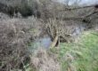
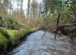
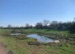
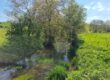
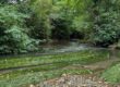
During the autumn of 2024, the BART project team walked every almost river, stream, ditch and rhyne in the system, surveying for habitat and water management improvements. BART also collected Environmental DNA (eDNA) samples for analysis from the pills, tidal gates, rhynes, ditches and watercourse flowing to the Severn Estuary, focussing on the Chestle Pill, and the Littleton and the Oldbury Naite rhyne systems.
Water samples were analysed for tiny skin and other fragments which can tell us what wildlife is present. We were looking particularly for signs of the European eel, (which has unbelievably become critically endangered in the UK since the 1980s) and for evidence of other fish and water-based mammals. The DNA found can tell you if a species was present nearby or upstream on that day.

Results
A link to the results is available here.
One of our most exciting finds was that the European eel was present in 18/25 samples – from Severn Beach and Easter Compton in the south through to Oldbury and Thornbury further north. Despite once being incredibly common around the Severn, eels are now critically endangered and are one of the UK’s most at risk species. A University of the West of England PhD student is onboard to undertake more focused surveys into eel distribution in 2025.
18 different species of fish were recorded across the three catchments. Flounder was a surprise finding. Not unexpected for near the River Severn but we now know they sneak a little inland. Thinlip Mullet and Sea Bass were also found just inland of the tidal gate at Oldbury. Quite how they get through the weirs and tidal flaps is unknown. As usual for the freshwater river samples, stickleback was the most commonly found fish species and occurred in all 25 samples. Brown Trout, often successful in hanging on in rivers which are otherwise in poor condition, were found only in only 8 of the 25 sites sampled.


As well as the fish data, the analysis picked up records of birds such as shoveler and teal, and mammals such as water vole and even a record of water shrew. This is exciting because they are so elusive. The team has been looking really hard and never seen one but the science can tell us they’re there!
Next steps include more eDNA surveys at different seasons and at new locations, more walkovers and water quality testing. These will feed into an action plan for fish recovery in the system that BART is preparing. The data will help inform future projects and action with a wide range of our partners which include the Environment Agency, Avon Wildlife Trust and the Internal Drainage Board.